We are pleased to announce that Applications and Entry to our new course – MRes in Advanced Spatial Analysis and Visualisation (ASAV) at the Centre for Advanced Spatial Analysis, University College London is now open. We have put together the course over the last few months to reflect the current state of play in geographic, urban and architectural information systems with an emphasis on visualisation, analysis and modelling. It is an innovative and exciting MRes which acts as a pathway to a PhD in ASAV.
Course Executive Summary
The Centre for Advanced Spatial Analysis (CASA) is an initiative within University College London to develop research in emerging computer technologies in several disciplines dealing with geography, space, location, and the built environment. As an interdisciplinary research centre expertise is drawn from archaeology, architecture, cartography, computer science, environmental science, geography, planning, remote sensing, geomatic engineering, and transport studies. The Centre is located within The Bartlett at UCL, from which it is administered but it has associated students and faculty in other faculties, specifically in Geography and in Civil (Geomatic) Engineering. This structure generates a unique blend of knowledge forming the core of the MRes ASAV.
The MRes is unique in its focus on complexity, modelling, mapping and visualisation, pulling together the latest research in urban form, functionality and communication. Recent changes in the rise of web-based technologies and the development of low cost yet complex visualisation and analysis packages has generated a notable change in the demand for more traditional vendor specific information systems and computer aided design courses.
The MReS ASAV reflects this change with a look towards Web 3.0 (Read, Write, Execute) technologies and methods to deliver skills required for current/future professionals and policy makers engaged in spatially related projects.
Curriculum Structure
The MRes in Advanced Spatial Analysis and Visualisation (MRes ASAV) is unique in its focus on complexity, modelling, mapping and visualisation, pulling together the latest research in urban form, functionality and communication. Recent changes in the rise of web-based technologies and the development of low cost yet complex visualisation and analysis packages has generated a notable change in the demand for more traditional vendor specific information systems and computer aided design courses. The MRes ASAV reflects this change with a look towards Web 3.0 (Read, Write, Execute) technologies and methods to deliver skills required for current/future professionals and policy makers engaged in spatially related projects.
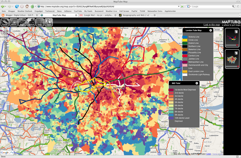
The course has a strong research component based around developing new methodologies from new task specific software and techniques that have emerged as part of what may be termed the ‘Web Revolution’. CASA has been at the forefront of these changes that have impacted the way we share, communicate and distribute information, specifically information relating directly to geographic and spatial entities. These changes have steadily emerged since the mid 1990’s and it is now quite clear that location and space now represent a third force in information technology besides more traditional computer and communication science.
We reflect these changes within the interlinked laboratory-research-based mini project with data collection focused on ‘remote data mining’ rather than fieldwork in the traditional planning/geographical/architectural sense. Indeed these research led skills are increasingly becoming a key element in shaping our understanding of complex spatial functions.
Vast amounts of previously unused data are becoming available either from changes in accessibility, due to the nature of the network and cloud based computing, changing national data policies or more widely as a result of new mass data collection methodologies.
The programme aims to provide training in the principles and skills of social and spatial research. Its aims include a strong understanding of qualitative and quantitative research methodology and methods of data collection and analysis to support and enable independent and group research projects. In addition to focusing on research skills, subject specific modules provide students with the opportunity to develop an excellence in spatial analysis with the specific skill set to engage and contribute to the current debates in urban and spatial continuums.
The course runs full-time over 12 months. The taught element of the course is delivered on two days per week over the first two terms.
BENVGSA1 – Group Mini Project: Digital Visualisation
The module introduces the students to methods of visualisation and data mining within the geospatial domain. Developed as a group project the module aims to provide an understanding of the juxtaposition between research, data capture and data display methodologies. As such the module is developed to build upon the taught sections of the course (BENVGSA3 and BENVGSA4) to develop initial research questions for the dissertation (BENVGSA2). Project assessment will be on a group basis.
Credits: 30
Terms: 1 and 2
BENVGSA2 – Advanced Spatial Analysis and Visualisation MRes Dissertation
The module is based around the writing, preparation of an original research project in the form of a Masters Dissertation. Students will be required to plan the research and dissertation from an early stage with ongoing development building on both the mini-project and taught courses developed through the year. The research topic will be defined under the guidance of the students dissertation supervisor with the support of the Course Director. The aim is to produce a unique, individual piece of work with an emphasis on data collection, analysis and visualisation linked to policy and social science orientated applications.
Credits: 90
Terms: 1, 3, 4
BENVGSA3 – GI Systems and Science
The aim of this module is to equip students with an understanding of the principles underlying the conception, representation/measurement and analysis of spatial phenomena. As such, it presents an overview of the core organising concepts and techniques of Geographic Information Systems, and the software and analysis systems that are integral to their effective deployment in advanced spatial analysis.
Credits: 15
Term: 1
BENVGSA4 – Spatial Modelling and Simulation
This course will introduce students to the
theory, principles and applications of mathematical and computer modeling as applied to cities. It will be based on five interrelated themes: an introduction to definitions of models as they relate to the philosophy of science; the model-building process involving calibration and prediction; types of urban models ranging from land use transportation models, microsimulation, discrete choice, cellular automata and agent-based models; the exploration of two specific types of model, namely land use transportation; and then cellular automata ABM.
Credits: 15
Term: 2
EDUCGE01 – Investigating Research
EDUCGE02 – Professional Development in Practice
ADMISSIONS
Informal enquiries should be directed to the course director, Dr Andrew Hudson-Smith.
To apply for a place on this course, please follow the directions from the UCL Admissions website.
Any chance this course can be taken on a part time basis?
The course is full time, however the timetable is structured to allow those wishing to adapt their hours and work load to attend part time if required. Do get in touch if you need any help with the timetable or hours.
Andy
Well done! This looks so promising.
Any chance this could be done on distance learning (for some or all of the courses?)
This is exactly what I was looking for since 2 years ago…. I am so frustrated that this master didn’t exist last year.. I just finished my master degree…and I can’t afford to start another one… I wish you all the best