
Atlantis Found in Google Earth?

By Atlantis, Google Earth


Google Earth 5.0 includes a view of the ocean bed and as such it allows global access to data that before its release was only available to specialist communities. As such it allows anyone in the world to look at put forward their own analysis which in turn opens up possible new discoveries – such as the possible finding of ‘Altantis‘ in an area area known as the Madeira Abyssal Plane.

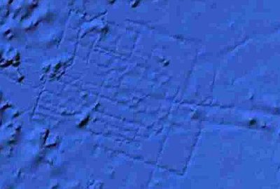
Discovered by spotted by aeronautical engineer Bernie Bamford as he browsed through Google Ocean the layout certainly appears man made and does open up questions of a lost city on the seabed.

The feature is quite notiable in Google Earth – you can zoom in direct with our file Atlantis.kml (right click to ‘save as’ and then open in Google Earth).

You can read full details in The Sun – we like the way they have manged to include a picture of Patrick Duffy with the story…

***Update***

As commented by M@ the Daily Mail are now running the view that ‘the photo, taken using Google’s latest gadget, Google Ocean, is nothing more than thin bands of sonar data collected by boats mapping the ocean floor’ – the see The Daily Mail for full info.

We still like to think its a lost city found by the power of the crowd…. 🙂

Dynamic Virtual Textures on a Digital Earth

By digital earth

We came across a paper this morning on Dynamic Virtual Textures by Javier Taibo, Antonio Seoane and Luis Hernánde from the research group VideaLAB at the University of Coruña.

As they state in the abstract the real-time rendering of arbitrarily large textures is a problem that has long been studied in terrain visualization. For years, different approaches have been published that have either expensive hardware requirements or other severe limitations in quality, performance or versatility. The biggest problem is usually a strong coupling between geometry and texture, both regarding database structure, as well as LOD management.

Their work paper presents a new approach to high resolution, real-time texturing of dynamic data that avoids the drawbacks of previous techniques and offers additional possibilities – take a look at the movie below detailing a 8 gigapixel images projected onto a virtual globe and updated every second:


The paper ‘
Dynamic Virtual Textures‘ (PDF link) is published in the Proceedings of the 17th International Conference on Computer Graphics, Visualization and Computer Vision ‘2009 (WSCG 2009) in co-operation with EUROGRAPHICS.

Urban Surveys: Unmanned Helicopters & Drones

By automatic city capture, unmanned drones

Unmanned aircraft, primarily helicopters capable of High Quality Digital Photography and HD Video are a low cost method to carry out rapid aerial surveys. Using remote control devices it is possible to fly through narrow areas such as city streets or natural obstructions at low or high altitudes. We are looking into this as at the moment due to our work on motion tracking in After Effects to label features in the urban realm (more details in a future post)

The clip below details New York captured using one of the drones:


New York City Aerial 1 – HD from David Quinones on Vimeo.

Take a look at http://www.skycamusa.com/ for full details, over the coming years unmanned drones are going to become a major part of monitoring, planning and surveying the city as costs are coming down to a pro-consumer level. As we mentioned in a previous post, the copyright issues associated with using other peoples data is often a nightmare, as such it is sometimes preferable to map/survey an area yourself.


This is where the Microdrone comes in handy – an unmanned aerial vehicle equipped with a digital camera and a GPS it provides an easy route for gathering data.

Of note in the specifications is the units ability to gather stereo data, allowing essentially a 3D model to be constructed from the flightpath. This combined with oblique imagery from the same flight opens up the prospect of texture mapped models of small areas.

The movie below shows the Microdrone in action:

The clip is slightly creepy to be honest with the unit peering into windows and spying on women on beach towels – the Microdrone also resembles the surveillance units in Half Life 2 featured in our movie below on the Architecture of City 17:


City 17 Architecture from digitalurban on Vimeo.

Bringing it back to geography and urban models, the movies would also be of use for camera matching allowing a local context for 3D models. In short we want one – sadly we cant afford a unit with prices coming in at 25,000 Euro.

You can buy one and find out more details from OrbitGIS.

Close Menu

About Salient

The Castle
Unit 345
2500 Castle Dr
Manhattan, NY

T: +216 (0)40 3629 4753
E: hello@themenectar.com

Archives