Sometimes when jumping from project to project and tutorial to tutorial projects get lost and posts overlooked.
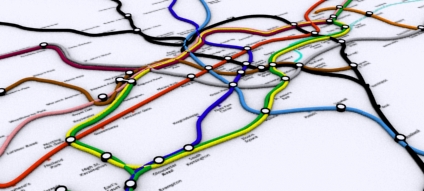
One such example is our 3D Tube Map which, despite being something we are quite proud off, sat on the shelf for a while due to lack of time. Embedded below is the project so far – click and drag to pan around and zoom in and out using the usual google map interface (created using our free Image Cutter Software):
UCL is currently working on a render farm of 250 or so processors for our London model, so fingers crossed the 3D Tube project will be back in movie form soon.
For those with eagle eyes we know of at least two ‘errors’ in the map 🙂 We will get these fixed and if anyone wants the image as wallpaper let us know your resolution and we’ll post up an image.
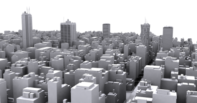
A city can be constructed using 3D Studio Max in under 5 minutes using the Greeble Plugin and a few simple steps. In the second part of our series on Greebling a City we take a look at creating the cityscape itself.
If your new to Greeble take a look at the first part of our tutorial: Greeble a 3D City: Tutorial 1: Greeble Skyscraper.
To build a Cityscape: You will need: 1x Copy of 3D Studio Max (a 30 Day trial can be downloaded from here) 1x Greeble Plugin installed into your Plugins Folder Time Required: 5 -10 Minutes Level: Beginner Step 1: Making a City Block
Create a new Plane object as pictured below, we used 100×100 units with 10×10 width and length segments (hint: press F4 to view the outline view if it is not visible): This creates our basic outline, we now want to convert this plane to a Editable Poly, to do this simply right click and select ‘Convert to Editable Poly’, as pictured below:
Step 2: Greeble the City
Now we have an editable polygon we can click on our Modify list and select Greeble: As soon as we click Greeble a basic cityscape will appear with small units on the roof and a low rise city block. There are a couple of tweaks we want to make to create a more city like view, firstly set ‘Taper’ to 0 and increase the height to say 35 units. This produces the city block illustrated below: You now have the basics for building a city, if you clone the block and change the heights in each section you will begin to build a background cityscape in which to insert various more detailed buildings as seen in our first tutorial. Road layouts can be included and more realism by including simple additions such as street lights and signage. Greeble can be an extremely useful tool for quick and easy city models, we hope this tutorial as provided an insight into how to quickly and easily build your own city.
Its taken a bit of time but our live weather data from the roof of CASA towers here in Central London is now back up and running. Complete with its own dedicated server the weather data is now available 24/7 and should form part of a wider network to create a 3D view of London’s urban heat island in Google Earth (more on that in coming months).
A few weeks ago we featured ran a post on Automatic Architecture: The CityEngine. The post looked into the procedural modelling of cities and more specifcally the work by Pascal Mueller a PhD candidate and research assistant at the Computer Vision Lab of the ETH Zurich, Switzerland.
Peter has teamed up with Peter Wonka from computer science faculty of Arizona State for a Google Tech Talk and at an hour long its worth grabbing a drink and sitting back and watching.
The abstract for the talk is as follows:
Creating digital content for virtual worlds remains a significant challenge, especially for urban environments, which are among the largest and most complex. As display capabilities improve and audience expectations grow, procedural modeling techniques are becoming an increasingly important supplement to traditional modeling software.
In this talk, we present grammar-based, image-based and interactive methods for the efficient creation of urban environments. Thus massive architectural models of high visual quality and geometric detail can be produced at low cost. Selected examples demonstrate solutions to previously unsolved modeling problems, especially to consistent mass modeling with volumetric shapes of arbitrary orientation.
Furthermore,we show massive urban models with unprecedented level of detail, with the virtual rebuilding of the archaeological site of Pompeii as a case in point.
The full talk is embedded below courtesy of YouTube:
Certainly one of the most interesting talks we have seen in quite a while…
Thanks go to Vint Falken for posting the comment that pointed to the tech talk, thanks Vint.