The Northern An Khanh New Town Development Project in Vietnam is the starting point of a new city. Development started in December 2006 and is scheduled for completion in June 2020 aiming to achieve a balance between Housing, Culture, Industry and Ecology.
Our interest lays in the promotional video, running at over 8 minutes it features some impressive animation, as it typical of high-spend projects requiring the best in architectural animation:
The city animation is stunning, so much so our suitcase was half packed before the animation finished. Digital animations of cities can be an effective marketing tool if used properly. Although a totally unfair comparison it put us in mind of the ‘Birmingham City of the Future’ movie on YouTube:
The film was made by Birmingham medical students for the Comedy Revue 2006, uploaded to YouTube by Matthew Doyle.
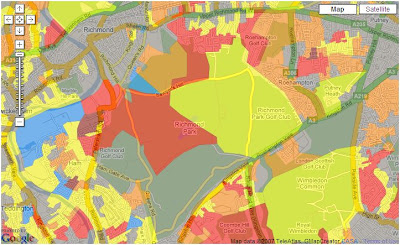
The image above takes away the natural geography of the city and replaces it with classifications of neighbourhoods – known as Geodemographics it provides an overview of the social and economic characteristics of your local neighbourhood.
The use of geodemographics details a unique insight into the city in terms of its cultural and social structure. This information is widely used by commercial companies to decide how to target customers with products or services depending on a number of classifications and in terms of academia it provides a good insight into the social geography of the county. As such the Output Area Classification User Group has been formed with the mission of promoting the use of the National Statistics Output Area Classification (OAC) and area classifications.
The Group is focused around the well established methods and output of area classification, but OAC is distinctive as it is in the public domain – a basis for ‘open geodemographics’ – encouraging interchanges between sectors on issues ranging from the underlying statistical methodology to interactive graphics for effective presentation. This open approach is possible as a result of relatively recent changes in the policy on access to government information.
Using our labs Google Map Creator it is possible to view the Output Area classification of the UK. The Output Area classification (OAC) distills key results from the 2001 Census for the whole of the UK at a fine grain to indicate the character of local areas. It was created in a collaboration between the Office for National Statistics (ONS) and the University of Leeds using the same well established methods as the related classifications of local authorities and wards.
Too date we have used the spheres to produce a sample high definition concept movie featuring 360 x 180 degree views of The Chapel of Peter and St Paul by Wren, Southwark Cathedral, The Painted Hall by Wren and St Giles in the Field, London.
Taking the concept further we have developed the Google Earth Panorama Viewer which takes images from Flickr or your hard drive and using a reversed face sphere allows you to ‘Step Inside’ buildings and scenes in Google Earth. The movie below highlights the idea and you can follow our tutorial to find out how to create your own:
Embedding Panoramic Spheres Inside Buildings
The same concept can be developed within the Oblivion Engine – again this is sample work while finding files to try out for the forthcoming second part of the tutorial. The movie below illustrates a panoramic ‘Step Inside’ sphere of the South Pacific Railroad in Oblivion:
“a 3 ft (914 mm) gauge narrow gauge steam railroad running between Santa Cruz, California and Alameda, with a ferry connection in Alameda to San Francisco. The railroad was created as the Santa Clara Valley Railroad, founded by local strawberry growers as a way to get their crops to market in San Francisco and provide an alternative to the Southern Pacific Railroad. In 1876, James Graham Fair, a Comstock Lode silver baron, bought the line. He extended the line into the Santa Cruz Mountains in order to capture the significant lumber traffic coming out of the redwood forests.
In 1887, the line was acquired by the Southern Pacific and the gauge standardized. In later years, the segment running between San Jose and Santa Cruz was used by SP’s “Suntan Special” which came down the San Francisco Peninsula and took passengers right to the beach and boardwalk in Santa Cruz. Service was disrupted by the 1906 Earthquake[1]. The tracks through the Santa Cruz Mountains suffered major damage during a storm in the winter of 1940, and the line was abandoned the same year.”
The panorama was captured in High Dynamic Range giving it a slightly unreal look: