
Photomodelling in SketchUp

By SketchUp


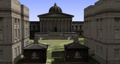
We have been working on internal software to allow rapid photomodelling in SketchUp. The software allows images to be rectified according to camera lens type to ensure height data can be accurately modelled and mapped in any 3D software package.

A movie of the model to date can be viewed here (167Mb 1280×780 .avi)

Using this technique you can quickly model for applications such as Google Earth or game engines. At the moment we have made good progress with the Oblivion Engine, we will post a movie of this as soon as we can. It is an interesting development route and hopefully opens up the ability to visualise architecture in games.

Google Earth Panorama – Taipei, Taiwan

By Google Earth Panoramas

Walker Young of the Taiwan 360 VR Panograph blog has used our tutorial on creating panoramas in Google Earth for his view of Taipei in Taiwan.

Interestingly he has used a Four Seasons to create the clouds above the city. Four Seasons allows the user to replace the sky in images using the ‘magic wand’ tool.

There are a number of cloud settings as well as the option to place the sun/moon in the image.

You can view the Google Earth Panorama of Taipei here.

Close Menu

About Salient

The Castle
Unit 345
2500 Castle Dr
Manhattan, NY

T: +216 (0)40 3629 4753
E: hello@themenectar.com

Archives