
Google Earth Canary Wharf

By Google Earth, Movies 10-20

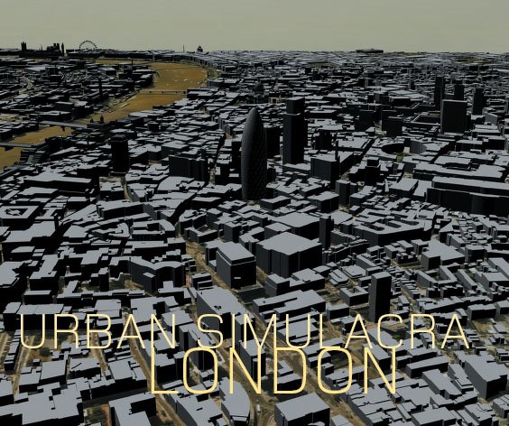
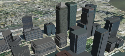
Last Friday we posted a movie created of Canary Wharf from simply downloading the models at the Google 3D Warehouse. The models were created by
Olivier Salome (with the tag Jef at the 3D Warehouse) and we asked him to get in touch.. thankfully he did and he agreed to a short interview into how he built the model and his future plans. He also allowed us to post his latest Google Earth file of Canary Wharf which can be found at the end of the interview and is well worth a download. If you havent seen the movie already you can view it by clicking play below:

1) I notice you are based in Brussels, what got you interested in modelling London?

I am amazed to see the huge building effort London is taking to transform its skyline. In the City of London, 30St Mary Axe (Norman Foster, 180m) is one of the most ingenious and elegant new skyscraper built anywhere in the world. It will soon be joined by other stunning structures such as e.g. 122 Leadenhall Street (Richard Rogers, 224m) and the Shard London Bridge (Renzo Piano, 306m). In the Docklands, Canary Wharf has become one of the most vibrant and fast growing new business district in Europe and its tallest tower at One Canada Square (235m, Cesar Pelli) is also a remarkable piece of architecture. Then I came to know the excellent modelling work undertaken at CASA/UCL and in particular the 3D London models shared on the blog. I was so impressed at the results that I decided to try myself some simple modelling exercises.


2) Distance modeling is never easy, how to you get your data.. more especially the outlines of buildings, the heights and the textures?

Emporis is one of the world’s largest publicly available database on architectural and building data. Plans related to planning applications are published on the websites of the Corporation of London and Tower Hamlets. Architects, developers and letting agents also release some of the information I need to undertake 3D modelling. I would also like to mention the London forum thread on skyscrapercity where quality pictures are regularly posted as well as relevant architectural information and links.

3) Can you give us an idea of your work flow?

It takes time to collect all the information before I can actually start modelling with Google Sketchup. Buildings at Canary Wharf are not difficult to model – compared to e.g. 30St Mary Axe. However, it is difficult to ensure consistency in terms of colours, especially for those buildings in stainless steel and glass. Overall it took me about a month to make that model.

4) What buildings can we look forward to in the future?

Canary Wharf has started its new phase of mid-rise developments around Churchill Place on the eastern edge of the cluser. The two “Pan Peninsula” residential towers at the adjacent Millennium Quarter are also under construction. These will be added to the model. I have also started modelling New Providence Wharf opposite the Millennium Dome and Ontario Tower which is due for completion later this year. Meanwhile I am working on some buildings in the City of London.

In some ways it is amazing how quickly 3D modelling of cities has essentially become Open Source thanks to Google Earth and modellers like Jef. You can download his latest version of Canary Wharf from here (6Mb) and we thank Olivier for his time and look forward to some more more buildings in Olivier’s section of the Google 3D Warehouse.

RealViz Stitcher 5.5 Unlimited vs PTGui Review

By Software Reviews

With the advances in stitching algorithm’s and panoramic head construction over the last few years the market for stitching panoramas has moved from one of manually placing control points to automatic alignment. With this expectations of the new release of Stitcher 5.5 Unlimited from RealViz are high, not least as for the first time Stitcher allows the use of fisheye images.

Competition in the panorama market is fierce with a number of competing products, of which the main contender is PTGui. PTGui, currently on version 5.8.4 retails at a price point of 65 Euro or roughly $80, Stitcher Unlimited on the other hand is $580 or 499 Euro.

We note that the automatic stitch function is only one aspect of both Stitcher and PTGui but from our point of view, and to compare the output of all the images in this blog, we are interested in ‘out of the box, point and click’ functionality. To compare the two packages we loaded in a set of images of St Peters Church in Soho, London which were captured with a Precision 360 panoramic head and a Nikon D70 10.5mm lens.

Both Stitcher and PTGui recognise the cameras EXIF data so there is no need to enter any lens parameters, as should be the case for a point and click automatic stitch setup.

The Stitcher interface is clean and intuitive; it is simply a case of loading the images in, accepting the EXIF data and selecting ‘AutoStitch’. PTGui is similarly straight forward although the interface is not quite as intuitive. We don’t intend to go into depth on the in’s and out’s of the packages but concentrate on the automatic output which is the important aspect in our current work flow.

This is sadly where Stitcher Unlimited 5.5 falls down. The company must realise that it is going to be compared directly against the likes of PTGui, to such an extent that posts on their forum mentioning the package are now banned. If this is the case you would of thought that RealViz would of made sure that Stitcher works ‘out of the box’, and in our tests this was simply not the reality of the situation.

Pictured above is a selection of errors in the output from Stitcher. The images speak for themselves and resulted in a panorama which was unusable, PTGui on the other hand, stitched the images with no notable errors that could be detected. Render times are also of note with Stitcher creating the panoramic scene in 6.47 minutes compared to PTGui’s 3 minutes and 50 seconds.

We are aware that reviews on the web are subjective and often opens oneself up to criticism. However, in our view, Stitcher should be able to compete with the much lower priced PTGui on the autostitch functionality. To find that it doesn’t is disappointing to say the least and you have to ask yourself what is RealViz doing releasing a package that it knows does not hold up to comparison with the competition which is less than a quarter of the price.

We like RealViz, they create some innovative software but Stitcher Unlimited 5.5 falls short and we can’t understand why.

Urban Simulacra London Paper

By Papers/Thesis, Publications

Recently we published the article ‘Urban Simulacra London’ in Architectual Design – Sensing the 21st-Century City: Close up and Remote.

As the digital revolution deepens and pervades every aspect of daily life, virtual realities begin to penetrate one another in a multiplicity of ways. The amount of sensing data being compiled on the city grows, enabling the construction of virtual realities that can, in turn, be transformed for diverse purposes.

Here, Michael Batty and Andrew Hudson-Smith from the Centre for Advanced Spatial Analysis, University College London, outline how they went about the construction of a virtual city in central London.

A conventional 3-D-GIS/CAD model was used as the basis on which to build a digital realm in which designers are cast as avatars and populations as agents, so as to define new ways in which to understand and plan the city.

You can read the article here (7Mb PDF). The original journal can be purchased from Wiley.

Full Reference: Batty, M., and Smith, A. (2005) Urban Simulacra: From Real to Virtual Cities and Back and Beyond, Architectural Design, Sensing the 21st Century City: The Net City Close-up and Remote, David Grahame Shane and Brian McGrath (Editors).

The CASA Book of GIS

By Papers/Thesis, Publications

We forgot to mention it on this blog before now but for those interested there is The CASA book of GIS which describes cutting-edge developments in GIS applications at University College London’s Centre for Advanced Spatial Analysis (CASA). Drawn from archaeology, architecture, cartography, computer science, environmental science, geography, planning, remote sensing, geomatic engineering and transport studies, these applications are emerging as the basis for spatial decision support systems across a wide range of industries and jurisdictions.

Accessible and innovative, these projects show how spatial analysis is essential to solving problems and creating insight into how people live and how their quality of life can be enhanced.

It includes a couple of chapters featuring earlier work from this blog and provides an interesting insight into the development and applications of GIS and visualisation in general. A link to the book via Amazon can be found in the side bar.

Close Menu

About Salient

The Castle
Unit 345
2500 Castle Dr
Manhattan, NY

T: +216 (0)40 3629 4753
E: hello@themenectar.com

Archives