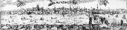
3D London Tube Map

By 3D London Tube Map, London Underground, Movies 1-10, Virtual London 5 Comments

A while ago we built a map of the London Tube network.. its neat but to be honest not all that much use (?). Somewhere on our hardrive is a real location of the map in 3D as well, we will hopefully dig that back out in a few days. You can view the current ‘classic’ London Tube Map below:

The reason for the post? We were going to add in depth data to produce a real representation of the tube network. Sadly due to security fears (which are understandable to say the least) this looks like it wont happen. Still, it would of made a neat flythough…

A higher res version can be found can be viewed from here (23Mb). Note the movie uses the DIVX codec.

Sketchup Google Earth Rapid Modelling

By Posts No Comments

Google had a stroke of genius when it purchased Sketchup and made it freely available. It suddenly opens up basic Computer Aided Design to the masses and with it the tools to model urban areas. If you run a simple search on London in the Google 3D Warehouse it become clear that something has started – people from all over the world are now modelling cities.

What is needed is simple to use tools so you don’t need mapping data or on site surveys, all you need is a digital camera. To this end Sketchup has come up trumps with the ability to push and pull images onto a face and recipe them. Sure its basic and the accuracy of your heights will be out but as a guide its a great way to push and pull buildings into shape rapidly.

Close Menu

About Salient

The Castle
Unit 345
2500 Castle Dr
Manhattan, NY

T: +216 (0)40 3629 4753
E: hello@themenectar.com

Archives