Twitter Data linked to Building Footprints

Tweet City: Building Heights by Number of Tweets Movie (London)

By 3D London No Comments

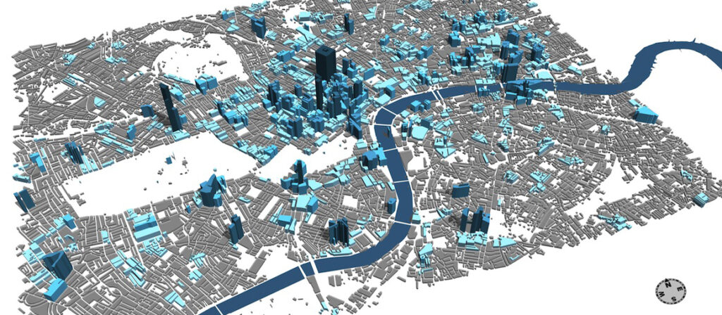
What if London’s buildings grew according to the amount of data they generate? Stephan Hügel (@urschrei) and Flora Roumpani (@en_topia) two of our PhD students from The Bartlett Centre for Advanced Spatial Analysis, University College London, have been working on a system to read in twitter data to CityEngine and link the geo locations to building outlines.
Twitter Data linked to Building Footprints

Twitter Data linked to Building Footprints

The video below is the first step in an approach to visualising an urban landscape using the objects that already exist in it; instead of abstract swirling points, bars, and artefacts hovering in the sky, the buildings themselves become the medium by which the data generated in and around them are made visible:

For more info head over to http://en-topia.blogspot.co.uk/2013/07/tweetcity-re-populating-london.html and to download source code: http://urschrei.github.io/CityEngine-…


Two New Lecturer Posts in CASA – Closing Date 12th July

By Posts No Comments
We are pleased to announce two new lecturer posts here at the Centre for Advanced Spatial Analysis:
Lecturer in Urban Analytics- Ref:1345485 
and
Lecturer in Spatial Modelling and Complexity – Ref:1345477 

Closing Date 12 Jul 2013
Latest time for the submission of applications 2pm
About CASA

The Bartlett Centre for Advanced Spatial Analysis (CASA) is an initiative within University College London to develop emerging computer technologies in several disciplines which deal with geography, space, location, and the built environment. As an interdisciplinary research centre expertise is drawn from archaeology, architecture, cartography, computer science, environmental science, geography, planning, remote sensing, mathematics, geomatic engineering, and transport studies. This generates a unique blend of personnel who operate from CASA and associated departments within UCL. CASA is a department within the Faculty of the Built Environment (http://www.casa.ucl.ac.uk).
Salary
Salary will be dependent on experience. The minimum spine point for a Lecturer is Grade 7 spine point is 33 (currently £36,064 including London Weighting).  Applicants with significant experience and research publications may be appointed on Grade 8.
How to Apply
To be considered for this position, please submit an electronic application, completing the UCL Application Form.
The online application system is accessible from: http://www.ucl.ac.uk/hr/jobs/
Full details of the posts and person specification can be found on the main UCL HR site: Lecturer in Urban Analytics and Lecturer in Spatial Modelling and Complexity

Augmented Reality UCL Map

UCL Live Campus Augmented Reality App – Created by Masters Students at CASA

By 3D Modelling, Agent Based Modelling, android, Augmented Reality, Game Engines, SketchUp, Unity 2 Comments

UCLive is an Augmented Reality Map of UCL developed by students on the Masters in Advanced Spatial Analysis and Visualisation at CASA. Featuring live data, the augmented reality android app works by simply pointing your mobile device at any of the UCL maps across campus.
Running in Unity and mixing a number of GIS and Agent Based Modelling elements, the development is outlined below:

  1. A three dimensional base model was created with SketchUp on top of the UCL campus map;
  2. Moving agents and transports are added into the application to show local bus and tube routes;
  3. Sounds are embedded into the application from the UCL Soundcloud;
  4. Online data on buildings, Twitter and PC Cluster availability  – live;
  5. The user’s location is shown in the application map.
Augmented Reality UCL Map

Augmented Reality UCL Map

Produced by  Ayana Kito ( http://3rdplat.blogspot.co.uk ), Balamurgan Soundararaj ( http://geoidin.wordpress.com ), Daniel Lam ( http://spatiametrics.wordpress.com ) and Nicola Clark (http://cityofblindinglights.org ) it represents the output of the final visualisation project on the masters course. The movie illustrates the app in action:
Take a look at the main UCLive page for full details and updates, we are currently exploring next steps to move the app towards release on Android and iOS.
You can still apply for 2013/14 entry to the MRes in Advanced Spatial Analysis and Visualisation the final full time deadline for applications: August 2nd.

UCL Quad - Lumion

UCL Quad – Procedural City and Lumion

By 3D Modelling, Lumion, UCL No Comments

The Quadrangle at University College London was designed by William Wilkins and constructed between 1827 and 1828. It is a natural building of urban research as its surroundings provide a mix of architectural styles. The 3D model of the quad was built using SketchUp with photos grabbed via a mobile phone – quick and simple.
UCL Quad - Lumion

UCL Quad – Lumion

Regular readers will recognise the model from our previous Elder Scrolls IV Game Engine work. We found the model on an old hard drive for a group of students working on a new UCL project. As such we took the opportunity to  load it into Lumion and add it into a future Bloomsbury created using CityEngine. Finally, the falling cubes (CASA branded, home of digital urban) are via 3D Max, linked in from a previous tutorial on Mass FX:

The building is centered on a Corinthian portico, after the completion of University College London Wilkins went to design the National Gallery in Trafalgar Square.

Close Menu

About Salient

The Castle
Unit 345
2500 Castle Dr
Manhattan, NY

T: +216 (0)40 3629 4753
E: hello@themenectar.com

Archives