
Power Outage on the du Servers

By Posts

The main power supply over in the florescent lit basement where the digital urban servers sit is being shutdown over the weekend for testing.

As such the blog will be missing images here and there so please accept our apologies for the shoddy nature of the posts over the next 48 hours.

Once all the safety boxes are ticked we should be back up and running in time for a new week…

Canon G9 Timelapse 1080p with CHDK

By canon, chdk, City Timelapses, G9

The movie below is our first timelapse test using the Canon G9, a power supply and the free CHDK firmware ‘addon’ for a range of Canon cameras.

Music ‘City Lights’ by Ox on MP3 Unsigned.

As mentioned, movie was created by capturing a 5 mega pixel image every 5 seconds, this allowed enough resolution to do the pan in post processing as well as the ability to crop out sections of the image.

As long as we got the settings correct you should be able to run the clip at 1920×1080 via YouTube. CHDK allows a wide range of Canon cameras to be used as timelapse rigs – indeed it arguably makes Canon the first choice for anyone wishing to creating an HD timelapse.

The movie is our first test, the technique should allow some good ‘stacked night time images’ of the city to be created – the image below was created from 8000 images to reveal activity in the sky above a city at night:

8401 Images Stacked: London Sky at Night

The image was created using a simple webcam – see our tutorial for more details, with CHDK we should be able to enhance this considerably.

HTML 5, GeoStyle Sheets and Vectors: Cartagen

By Posts

Perhaps we need to get out more, but we are getting quite excited about the possibilities of HTML 5. The ability to build applications that run naively in the browser without the need for plugins will allow agencies such as the police, government, health service etc a to view data that is currently restricted due to rules on installing plugins/software on networks.

As such imagine our joy when we discovered Cartagen – a vector-based, client-side framework for rendering maps in native HTML 5. Written in JavaScript, it uses the new Canvas element to load mapping data from various sources, including OpenStreetMap. In short, Cartagen lets you make beautiful, customized maps with a simple stylesheet.


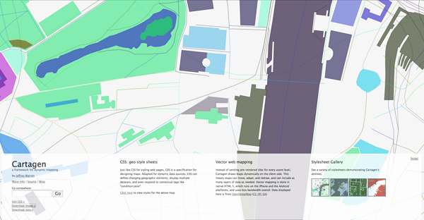
Maps are styled with Geographic Style Sheets (GSS), a cascading stylesheet specification for geospatial information – a decision which leverages literacy in CSS to make map styling more accessible. However, GSS is a scripting language as well, making Cartagen an ideal framework for mapping dynamic data.

Head over to Cartagen for a look, thanks a lot to Kirk of MossCreekMedia for sending this one in.

Close Menu

About Salient

The Castle
Unit 345
2500 Castle Dr
Manhattan, NY

T: +216 (0)40 3629 4753
E: hello@themenectar.com

Archives