 Marcus Foth in the edited book entitled “Handbook of Research on Urban Informatics: The Practice and Promise of the Real-Time City” brings together in 29 chapters on recent research and development in the field of urban informatics from around the world. The book covers a plethora of topics including; community engagement, digital cities, digital identities, locative media, mobile and wireless applications, participatory planning, personal privacy, surveillance and sustainability.
It is a rather good book and the publishers have kindly allowed us to make our chapter ‘The Neogeography of Virtual Cities: Digital Mirrors into a Recursive World’ available online.
Abstract
Digital cities are moving well beyond their original conceptions as entities representing the way computers and communications are hard wired into the fabric of the city itself or as being embodied in software so the real city might be manipulated in silico for professional purposes.
As cities have become more “computable,” capable of manipulation through their digital content, large areas of social life are migrating to the web, becoming online so-to-speak. Here, we focus on the virtual city in software, presenting our speculations about how such cities are moving beyond the desktop to the point where they are rapidly becoming the desktop itself. But what emerges is a desktop with a difference, a desktop that is part of the web, characterized by a new generation of interactivity between users located at any time in any place. We first outline the state of the art in virtual city building drawing on the concept of mirror worlds and then comment on the emergence of Web 2.0 and the interactivity that it presumes.
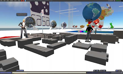
We characterize these developments in terms of virtual cities through the virtual world of Second Life, showing how such worlds are moving to the point where serious scientific content and dialogue is characterizing their use often through the metaphor of the city itself.
You can download the full chapter here (pdf link)
 Navigating the city on foot can be tricky, sure an iPhone may help but who wants to walk around with a shiny new phone in your hand just waiting to be stolen? How about a pair of shoes with GPS built in, complete with step by step guidance. The left shoe holds all the gadgetry: under the tongue you will find the control unit. Just enter your starting and destination postcodes and you’re off.
 There are two ways Sat Nav Shoes give you directions. An LED DNav Bubble on the front acts as a visual guide and you’ll hear a beep when you are heading in the wrong direction. The heel of the shoe is equipped with waterproof speakers or for those with wireless headsets, bluetooth.

