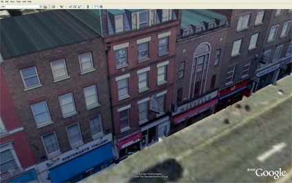
We have placed online a first draft output using our in-house software to obtain accurate height/facade data from photographic modelling. Using a camera calibrated algorithm we can ensure accurate placing of windows/doors etc to rapidly create city models.
With the beta version of Google Earth, these can then be easily imported and viewed. The software is currently being developed, if you would like further details please feel free to email.
You can download the kmz file to fly into the model in Google Earth here (4Mb)
Sample Photomapping in Google Earth
Andy
CASA, UCL East
Recent
The Papers: The 2nd Album
Spatial Computing and the Phygital City: Towards Digital Habitation
Color Weather: A Data Watch Face for the Pebble Time 2
Fenland: A weeWX Dashboard with forecast verification, ensemble models, climate records back to 1940 and finally, that tween...
City Clock: A City where the People Tell the Time