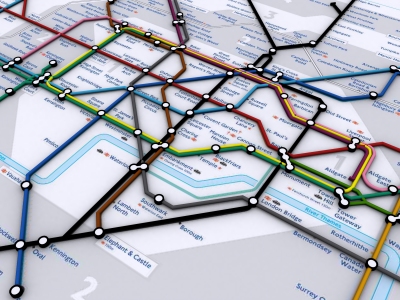
A while ago we built a map of the London Tube network.. its neat but to be honest not all that much use (?). Somewhere on our hardrive is a real location of the map in 3D as well, we will hopefully dig that back out in a few days. You can view the current ‘classic’ London Tube Map below:
The reason for the post? We were going to add in depth data to produce a real representation of the tube network. Sadly due to security fears (which are understandable to say the least) this looks like it wont happen. Still, it would of made a neat flythough…
A higher res version can be found can be viewed from here (23Mb). Note the movie uses the DIVX codec.
A 3D representation of parts of the tube network with interconnecting tunnels and street exits would be brilliant, and also really helpful for commuters to identify easier routes. I wouldn’t have thought it would represent a security issue as you wouldn’t outline security lapses or areas not covered by CCTV. Please persue the idea, if only concentrating on the Kings Cross area, it’d be fascinating!!
Kev
How can I obtain this 3D file?
Well, someone somewhere was recording information about depths of stations, by counting the number of steps down… Can’t remember where…
I guess you could work out the layout of stations just by walking around them and taking notes – might get you arrested though. Alternatively, just a good memory would do – I’m sure some people know the stations well.
I guess TFL have maps for all the stations, just need someone to leak them 🙂
Keep pressing – I love the Tube and a genuine 3D representation would be brilliant.
Thanks.
Mark
Don’t forget The Way Out Tube Map is avilable in good old fashioned paper form!