
Live London Dashboard now with realtime Olympic tweet counter

By Front Page No Comments

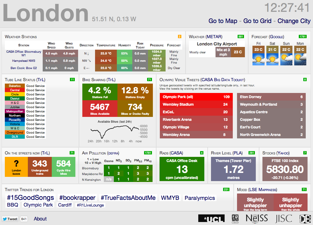
Ollie here in CASA has just posted a new temporary panel on the London CityDashboard which shows Twitter activity at the London 2012 venues. The panel is using data from new Twitter collector tools in the Big Data Toolkit, developed by  Steven James Gray, again CASA, as part of his PhD.

As Ollie notes ‘for each venue, the collectors count the number of Tweets in the last hour that have latitude/longitude information stamped on them, that are located within an area radiating around the centre of each stadium or arena. Its worth noting that this excludes the majority of relevant tweets, as most mobile Twitter applications don’t include this information by default’, you have to turn on Geo Location.

So far the Olympic collectors set up by Steven (@frogo) have 22 machines each collecting Tweets from each of the Olympic venues all over London and we have managed to collect over 1.4 million tweets from the last 14 days of the Olympics (Each has been sent from the vicinity of each venue hence why the individual numbers are low).
The Big Data Toolkit will be entering a beta testing phase in the next couple of months, to allow anyone to collect and map tweets – the aim is to make it as easy as possible while also maintaing the feed for data analysis.
You can view the live data either within our other feeds via our London CityDashboard or direct at http://bigdata.casa.ucl.ac.uk/olympics/
For more detailed information take a look at Ollie’s Suprageography site and Steven’s Big Data Toolkit.
 

Using Oyster Card journeys to understand how, why and where we travel in London

By Front Page, Slider 2 Comments

Researchers from UCL have analysed millions of Oyster Card journeys in a bid to understand how, why and where we travel in London.

Professor Michael Batty (UCL Centre for Advanced Spatial Analysis) and Dr Soong Kang (UCL Management Science and Innovation) applied the techniques of statistical physics to their mountain of raw data.

The pair joined forces with a computational social scientist and a physicist, both based in Paris, to explore patterns of commuting by tube into central London:

They used Transport for London’s database of 11 million records taken over one week from the Oyster Card electronic ticketing system.

Raising Risk Awareness on the Adoption of Web 2.0 Technologies in Decision Making Processes

By Front Page, Future Internet No Comments

Future Internet has published the latest paper as part of the Special Issue Government 2.0 entitled Raising Risk Awareness on the Adoption of Web 2.0 Technologies in Decision Making Processes by Marco Prandini and Marco Ramilli of the Università di Bologna:

Abstract
In the recent past, the so-called “Web 2.0” became a powerful tool for decision making processes. Politicians and managers, seeking to improve participation, embraced this technology as if it simply were a new, enhanced version of the World Wide Web, better suited to retrieve information, opinions and feedbacks from the general public on subjects like laws, acts and policies. This approach wa
s often naive, neglecting the less-obvious aspects of the technology, and thus bringing on significant security problems. This paper shows how, in the end, the result could easily be the opposite of what was desired. Malicious attackers, in fact, could quite easily exploit the vulnerabilities in these s
ystems to hijack the process and lead to wrong decisions, also causing the public to lose trust in the systems themselves.
Keywords: Web 2.0; e-government; security; decision making
You can view the full paper over on Future Internet.

Kickstarting Open Source City Software: Transit App for iOS 6 and Beyond

By Front Page, iphone app No Comments

The way we get around is changing. We increasingly combine bikes and transit. And in many cities we’re seeing a birth of whole new modes of transport like bike-share and carshare. Over at OpenPlans they build open source tools that are responsive to these changes and let us imagine new ways of moving and with the announcement of iOS version 6, Apple has dropped Google Maps and with it, previously built-in support for travel directions via public transit they are looking to kickstart a solution :

 
With support, OpenTripPlanner Mobile, an open source application developed by OpenPlans will put transit back on the iPhone.
The app will also add new features that Google Maps didn’t have, allowing users to combine walking, bikes, bike-share and transit together, finding the fastest and most efficient trips regardless of mode of transportation.

The people over at OpenPlans are a talented bunch, their New York Bike Share Trip Planner for example is nicely done. The more funds they raise the more features and data coverage they be able to add. We like the fact that all of the data and source code created as part of this project will be made  available for free as open source. Also, OpenPlans will release a developer API that allows you to access the back-end trip planner as a hosted service.
Open source tools to help make cities better, head over Transit App on KickStarter, at the time of writing they have raised $12,299 out of the $25,000 goal.
Thank go to the Urban Mobility Daily

Close Menu

About Salient

The Castle
Unit 345
2500 Castle Dr
Manhattan, NY

T: +216 (0)40 3629 4753
E: hello@themenectar.com

Archives