Sneak Peak: QRCodes and iPads in The Grant Museum

By digital heritage, digital humanities, digital museums, ipads, QRator, tales of things, UCL One Comment
Here at University College London, the Grant Museum of Zoology, which contains some of the rarest extinct animal specimens in the world, is to re-open on 15 March, 2011 after an eight-month renovation and moving period. Over the past few months we have been working here in CASA with the nice people over at the Centre for Digital Humanities and UCL Museums to build interactive signage for the exhibits.
Based around the ‘Tales of Things‘ technology, each artefact has a QRCode and Twitter Hash Tag allowing digital conversations to be carried out both inside and outside of the museum space. In typical ‘sneak peak’ photo mode, below is a look at one of the iPad mounts:

We are not sure why all first look photos are blurred, but such is the case. The project, known as ‘QRator’ is placing 10 iPads around the museum to explore new models for public engagement and informal learning in museums using handheld mobile devices and new interactive digital labels. The aim is to enable the public to collaborate and discuss museum concepts and object interpretation with museum curators, and academic researchers.
Wired UK has a good article on the Museum with a mention of QRCodes, for a more in depth view of such matters head over to Digital Nerdosaurus.
We will have much more on QRator over coming weeks….

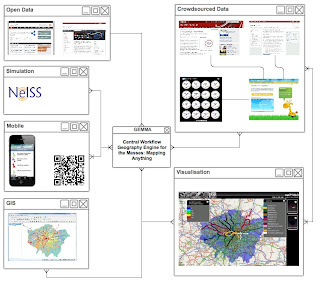
Introducing GEMMA: A Geospatial Engine for Mass Mapping Applications

By GEMMA, Geospatial Engine, inf11, JISC, jiscgeo, map mashups, mass mapping, Neogeography, Projects 2 Comments
GEMMA is the latest in a series of geospatial projects from the Centre for Advanced Spatial Analysis, here at University College London.
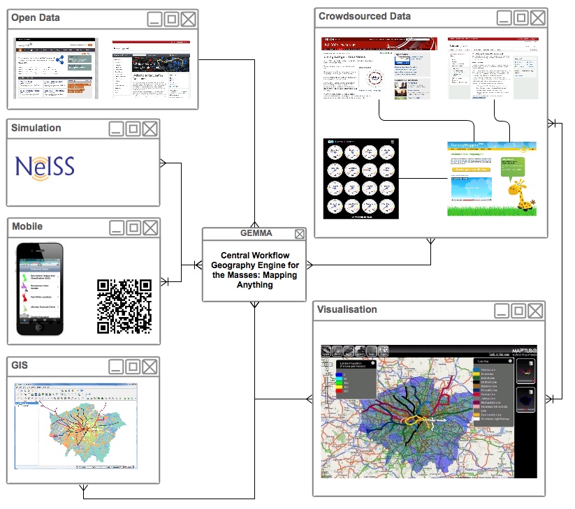
We are experiencing a massive explosion of online geospatial data from many new and unconventional sources from mobile devices to crowd-sourcing tools. Combined with newly released public sector information, we desperately need to integrate our tools for unlocking, exploiting, understanding and sharing these new data sets so that users can be provided with an accessible gateway to their display, mapping and spatial analysis.  Funded by JISC, GEMMA aims to produce a single workflow for the collection, mapping, preservation, sharing and visualisation of the geospatial datasets.
The Aim of GEMMA
What does that mean in short? The ability to create a map without knowing anything about mapping. Simple as, for too long creating a map has been too complicated, there is now a vast amount of geographically tagged information available online, yet to map it you still have to have a considerable amount of computer related knowledge. Not any more, and we are not talking standard pin type maps, we will enable complex spatial mapping to be carried out at the click of mouse and a point at a file.
 
This is what geospatial mapping should be, GEMMA aims to  bring ‘geo’ to the masses and not in a ‘neogeo’ type way, simply find some data, make, mix and display a map, that’s GEMMA in a nutshell.
 
 
With applications as wide ranging as community participation, social simulation, economic analysis, urban modelling and beyond, the collection, visualisation, analysis and ultimately understanding of these datasets requires new software organised around a new series of workflows which integrate an array of tools.
Over the next 8 months we aim to produce a one stop shop for any user who wishes to take public sector, crowd-sourced, mobile and related online data with geospatial reference which enables them to display and overlay this information in non-proprietary or freely available mapping services on the web such as Google Maps or Open Street Map, building on several tools that CASA has developed such as, MapTube and SurveyMapper.
What to Expect?
 
In typical CASA style, we will have frequent updates, beta releases and online apps. GEMMA will be integrated with various crowd sourced and open data sources complete with both iPhone and Android applications for viewing and collecting data in the field.
GEMMA kicks off March 1st, 2011, its time to make geo easy….

Broadband Speed Mapped for BBC Look East Research

By Crowd Sourcing, free survey tool, Neogeography, poll, social simulation, surveymapper No Comments
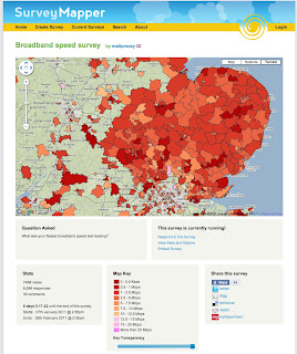
BBC Look East is calling for people in the East of England to find out their home broadband speed, as part of the TV programme’s week-long special – using our free SurveyMapper tool, at CASA, University College London, to collate and map the results in real time. So far over 6500 responses have been received.
It is estimated only 60% of households in the region have access to high speed broadband.
Look East’s business reporter Richard Bond said that the figure was unlikely to grow much in the next five years.
Home broadband users can take part by plotting their speed onto an interactive map.
The results of the research will then be shown on BBC One during Look East’s broadband week, which runs from 21 to 25 February 2011.
“Fibre optic networks, the key to a fast service, are only available to people in and around the major towns and cities,” said Mr Bond.
“Broadband speeds in rural areas are slow because they depend on copper telephone exchanges.
“Although BT is rolling out its fibre optic network, this is unlikely to make much of a difference to most rural communities over the next five years,” he added.

Speed test

Broadband users can test their upload speed on BBC News’ Technology website.
As broadband speeds on the same connection can fluctuate, it is recommended that people take the test several times and make a note of the highest speed.
Other speed-testing websites could return different results, so it is recommended for this research that third-party sites are avoided.
Once a figure is obtained, people can then plot their results on the BBC Look East map hosted on our SurveyMapper.
It is nice to see maps and indeed crowd sourced surveys used in such a way, SurveyMapper has been developed as part of NeISS (National e-Infrastructure for Social Simulation, funded by JISC as part of its Information Environment Programme.
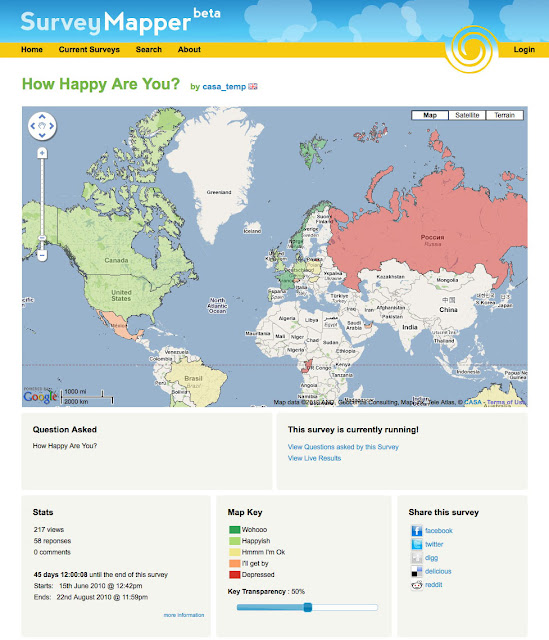
You can set up your own survey or poll on SurveyMapper – If you have used other ‘polling sites’ then you will be up to speed, except we have taken away the restrictions and added real-time mapping into the mix. Simply sign up (its free) and then your be able to create your own survey and embed it into your own site. Currently we have five levels of survey available – Worldwide, based on coun
tries, European Countries US Zip Code, UK Postcode and a Drag and Drop Pin Map.


You can ask anything, survey the nation, the world or just your street with real-time mapping and statistics.


To take part or create your own survey head over to SurveyMapper.com

The Look East survey runs until February 25th with updates each evening on BBC Look East News.

3ds Max 2011 One Project from Start to Finish – Retweet to Win a Copy

By 3dats, 3dsmax, Book Reviews, competition No Comments

*Update*


Thanks to everyone who retweeted and entered the competition, we are pleased to announce the 3 winners:

CodeDependent
thesuitcasekid
imagineer360

If the winners could email us their address we will ship the books out asap.


Sorry if you did not win this time round, we will have more ‘giveaways’ soon…

***

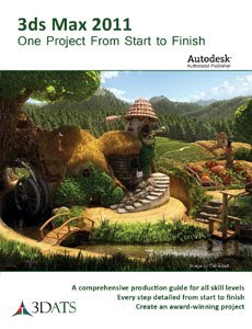
3ds Max is a uniquely powerful modelling program, yet one that can catch out both new comers and even advanced users out with its intricacies and workflows. Many tutorial style books are fundamentally flawed by assuming the reader is already familiar with various aspects of the software. Indeed, we remember well a book that stated ‘now complete this easy step’ only to leave us both frustrated and annoyed as we failed to grasp the instructions.

What therefore is needed is a book that illustrates the process of creating a 3D visualization project step by step – and we are pleased to say there finally is a book worthy of its title ‘3ds Max 2011, One Project from Start to Finish’.

The movie below details the model produced over 9 chapters and the good news is we have three copies to give away, full details at the end of the post:

The book has been designed to be useful for readers at all skill levels. The material is presented in a way that will engage advanced users while still being explicatory enough for beginners – which is great to see.

Covering 2D-3D Modelling, Terrain Creation, Tree Creation, Water Elements, Animation, Lighting, Rending, Particles Systems and more the book provides a fully structured guide.

If your only going to buy one 3D modelling book this year then 3ds Max 2011 – One Project from Start to Finish is simply the best option.

The publishers 3DATS have kindly provided us with 3 copies to give away to readers – simply retweet this post and we will pick 3 winners at random from the Twitter feed. Competition ends 28th February, so you have a week to enter.

The retweet button is at the top of the post, good luck, books will be shipped Tuesday 29th, each valued at $99.95.

Close Menu

About Salient

The Castle
Unit 345
2500 Castle Dr
Manhattan, NY

T: +216 (0)40 3629 4753
E: hello@themenectar.com

Archives